Smoke Impact Summary #12 Soberanes Wildfire
Air Basin: North Central Coast CAL FIRE IMT
4 w/ USFS
Issued for August 9th, 2016 Prepared
by: Gary M. Curcio ARA
Time 7:00 PM Steve
Fraidenburg ARA (T)
Fire Status & Key Points:
1.
Total fire acreage has been adjusted today at 67,383 acres and 60% containment.
2. Yesterday burning expanded estimated growth by 6,924 acres.
3. Projected smoke emission impact for tomorrow, Wednesday August 10th is estimated at
5,000 Acres. This includes:
a.
2,500 acres for the Burnout operations on
the east and southwest sides.
b.
1,250 acres free burning on the southern fire
perimeter (near Elephant Mtn.)
c.
1,250 acres free burning where the fire
crossed the South Fork of Little Sur
4. Extended
Outlook: “future smoke emission acreage” is now estimated at 12,000
acres. This figure was projected based on the tactical options presented on
August 9th. Depending on weather, fire behavior and suppression
accomplishments, this acreage can be considerably different. It will be revised as necessary.
5. Extended
Outlook: “future smoke emission acreage” is now estimated at 12,000
acres.
This figure was
projected based on the tactical options presented on August 9th.
Depending on
weather, fire behavior and suppression accomplishments,
this acreage can be
considerably different. It will be
revised as necessary.
6. The
weather today was primarily influenced by the marine layer. The weather tomorrow
will be marine layer influenced but may have
slow movement north at higher elevations
when marine layer clears. Lower elevation burning will increase
smoldering combustion.
It is expected this will still degrade AQ at the
surface in Big Sur, Salinas Valley
and the Carmel
Valley for another day. Potential exists
for northern communities such as
Carmel and Monterey to have AQ impacts in the
afternoon.
Laureles
Grade Rd. vantage point looking approximately S. Plume vertical lift is marginal as it was not able to rise above
the inversion and its drift to the E
6.
IR Fire Perimeter & Modis Heat Signatures 8/9 at 7:15 PM
The Photo identifies active burning on the fire’s SE corner & the SW corner.
Mop-up continues.
The S side (center area) of the fire
growth continues to occur. These are major emission sources. They continue to impact
Big Sur, Carmel, Salinas and San Joaquin Valley & their respective communities.
Southern flow aloft will be mild but may push smoke into communities in the
north, particularly Salinas and Monterey. IR heat intensities from the previous
night are identified. Areas of intense
heat are red shading. Scattered heat is yellow shading. Isolated heat spots are
red dots. These heat intensities are still numerous. They are sources of
emissions and in combination with free burning and burnout operations, continue
to affect AQ in local communities.
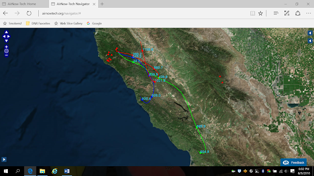
7. Soberanes Fire
Trajectories from two major sources of emissions .
24 Hour trajectory for altitudes: 10 meters
(green), 100 meters (blue),
and 250 meter (red) from point near Elephant Mtn.
ran from 1400 on August 9, 2016.
8.
The Soberanes
Fire smoke production and its long range drift are displayed below. It is anticipated
that this
smoke will drift more northerly tomorrow.
Photo: NOAA Hazard
Mapping System - 8/9/16 PM.
Smoke from Soberanes continued to move north & east but
did not travel as far as past days.
Image appears to compile smoke from
multiple fires in California.
1) Green = light,
2) Yellow = medium &
3)
Red = dense (only shown in the left picture).
These colored layers are not
defined by their elevation above ground.However, they do provide valuable
information concerning the horizontal extent of wildfire’s smoke plume and its
zone of influence.
9. Smoke transport winds were WSW. The wind speeds were
such that the plume did not travel the distance seen yesterday. This was
captured in the NOAA Visible satellite imagery. The Big Sur, Carmel, and
Salinas Valley were impacted. San
Joaquin was also impacted. Arrow points to smoke drift line.
Important Note:
Wednesday:
Low clouds and coastal drizzle with the marine layer
around 1500 ft. Clouds erode back to the
coast by mid-late morning. Wind direction will vary greatly across the fire
today with a more southerly influence over Big Sur and a northerly influence
over the east, especially over mid and lower elevations. Temperatures and
humidities will be within a few degrees of Tuesday’s values. The marine layer will build back in Wednesday
night, but begin to compress as high pressure begins to build over the
region. As a result, a more noticeable
drying will occur over the higher peaks Wednesday night.
Thursday: High pressure ridge is still forecast to build over the region Thu-Fri with warming and drying trend. The building ridge will also compress the marine layer.


No comments:
Post a Comment